What do you want to Enquire about?
About Us
Who We Are
RV PLANET PRIVATE LIMITED is an industry leader in Geospatial and IT Utility consulting services, founded in 2019. We are the pioneer in surveying, advanced mapping, and geospatial services. With the professionals and rich experienced team, we deliver expert services in Geographical Information System (GIS), Geospatial Engineering, Environmental Studies, Agricultural mapping, natural resources monitoring, IT domain, etc.
Our Mission
Our motive is to inspire a culture of safety and safe work practices. Innovation is in our heart whatever we do. Our experts are not only on the cutting-edge of collecting, maintaining and distributing data, but continually seek new and relevant ways for customers to get the best from it. Our attitude is providing valuable solutions and their timely and cost-effective services.
What We Do
RV PLANET PRIVATE LIMITED is having experienced manpower with relevant qualification and experience to provide the most appropriate and time stringent solutions to the customer. We work with every imaginable type of data, from modeling algorithms, to real-time polling data, to satellite monitoring to ground based analysis, to disease tracking, collection of community-based data on a socioeconomic survey, livelihood survey, and evaluation studies, etc. We combine and analyze data to derive insight that tell powerful stories. We strategically use open source data & license data to drive social and economic development.
View more
Our Leadership Team

Mr. Jay Kumar
Business Head
Products & Services

IT Development
Product Detail
IT Development
- Software Development
- Website/Web APP development
- Android Development etc.
+ Show more
- Show less

Ground Survey
Product Detail
Ground Survey
- House to house data collection
- Socio-economic surveys
- Ground control survey using DGPS
- Utility survey using GPS
- Reduced Level survey using DGPS
- Livelihood surveys
- LiDAR, Total Station etc.
+ Show more
- Show less
Environmental Analysis
Product Detail
Environmental Analysis
- Water sampling for quality
- Agricultural mapping
- Soil sampling
- Soil quality and soil moisture analysis
- Thermal RS data mapping
- Land surface temperature mapping
- Data analysis
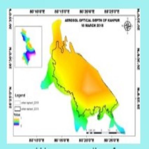
- AOD Monitoring
- Wasteland development
- Soil conservation
- Watershed mapping
+ Show more
- Show less
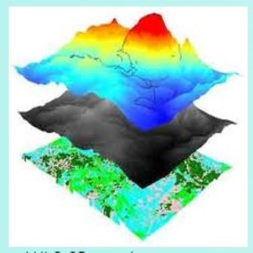
RS and GIS Services
Product Detail
RS and GIS Services
- LULC, 3D mapping
- Thematic mapping, Sustainability etc
- High Resolution satellite Image (HRSI)
- Urban sprawl map
- Village information system
- Spatial Distribution of pH
- Cadastral Mapping
- Digitisation
- POI expert
- 3D building etc.
+ Show more
- Show less